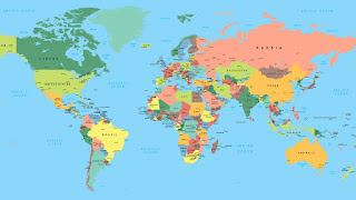
A map is a drawing of a specific area, e.g. A city, country or continent showing the main features as they would appear when viewed from above. The map is a symbolic representation that emphasizes the relationships between elements of a space such as objects, regions or themes. Many maps are static, mounted on paper, or some other durable medium, while others are dynamic or interactive.
The person who makes maps is known as a cartographer.
The first printed “modern map” is in an encyclopedia called Rudimentum Novitiorum.
Cartography refers to the study of maps and mapmaking.
Modern mapmakers often incorporate fake towns into their maps on purpose. These are known as “paper towns”, “phantom settlements,” or (for some reason) “bunnies.” The thinking behind this is that if the cartographer comes across another map with the same fake town, they know it is a copy!
During the Middle Ages, the majority of western maps placed east at the top instead. The reason being, in Latin, the word of the east is ”oriens.” Therefore, to hold the map properly, they had to ”orient” it to ensure that the east is east. It happens to be the origin of the word orientation.
The map that’s familiar to most of us is the Mercator projection, it’s been a fixture in classrooms and world atlases for nearly 500 years.
In 1798, James Rennell drew the first map of Africa showcasing the massive Mountains of Kong.
North may be at the top of maps today, but that wasn’t always the case. During the middle ages, most Western maps put east at the top instead.
In the French caves of Lascaux, there’s a map of stars that’s believed to be 16,500 years old.
Throughout Medieval times in Europe most maps of the world, known as Mappae Mundi, were expensive to create by hand, so were used by Royals and Nobles as displays of wealth rather than for practical purposes.
The Waldseemüller map, drawn in 1507, by German cartographer Martin Waldseemüller, is the first recorded instance of the word “America” appearing in a map.
During World War II, silk maps were sealed into Monopoly games, along with real money hidden among the fake, and new games pieces such as a working compass. These special games and maps were then sent to war camps to help prisoners escape.
The only known copy of The Waldseemüller map is with the U.S Library of Congress. It was purchased by the library for U.S $10 million, making it one of the most expensive maps ever to be sold.
The only kind of map of the Earth that is not projected is one drawn on a sphere. This is called a globe.
The oldest known map is not of the Earth but of the stars. In 2000, a map of the night sky was discovered in one of the caves in the cave complex at Lascaux, France and is believed to be more than 16,500 years old.
Many maps today are made using GIS computer systems. These are database systems that are organized by location instead of named records.
Governments prohibit the publishing of maps with locations of military installations, security bases, communication towers, and defense installations.
The word “map” can also be used to talk about a chart or drawing that shows relationships between ideas, people, events, or anything else you can think about. This is why web developers call a list of web pages on a web site a site map.
The oldest sphere on record dates back to around 1,500 and is engraved on the surface of an ostrich egg. It also marks the first time the idiom ”here be dragons” appeared on a map. It was written in Latin’ Latin’ hic sunt dracones.”
A map that shows an area in great detail, such as a street map of a neighborhood, is called a large-scale map because objects on the map are relatively large.
Google has created at least one paper town in Argleton, England. It was discovered on Google Maps in 2008, although the location was not a town but empty land. Later, they removed it, and no one knows if it was a copyright trap.
A map of a larger area, such as a continent or the world, is called a small-scale map because objects on the map are relatively small.
The first known map for putting North on top and South at the bottom is from Korea. It was created in 1402 by Kwon Kun, an astronomer and the map is known as the Kangnido map.
Many computerized maps allow the viewer to zoom in and out, changing the scale of the map.
Eskimos carved maps out of ivory while the Incas made relief maps of clay.
Some maps show relief, or changes in elevation. A common way to show relief is contour lines, also called topographic lines. These are lines that connect points that have equal elevation.
The Chinese wrote about maps as early as the 7th century, B.C.E.
Many maps include a grid pattern, or a series of crossing lines that create squares or rectangles. The grid helps people locate places on the map.


